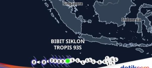
Jakarta – BMKG said the seeds of tropical cyclone 93S are moving away from Indonesian territory. However, BMKG predicts that tropical cyclone seeds will continue to affect the weather in Indonesia. The warning about the potential for tropical cyclones was conveyed by BMKG in the Tropical Cyclone Seed Analysis document 22 December 2025 at 07:00 WIB seen by detikcom, Monday (22/12/2025). BMKG initially said that the seeds of tropical cyclone 93S, which started forming in the Bali-West Nusa Tenggara region on December 11, 2025, moved to coordinates 12.3°S 102.6°E in the Indian Ocean southwest of West Java. This position has shifted compared to the analysis on Sunday (21/12) morning. BMKG said the maximum wind speed observed was around 65 km/h with a minimum air pressure of 998 hPa. Based on observations of satellite images in the past 12 hours, BMKG said, there was a decrease in convective activity on December 21, 2025 at 21:00 WIB to 07:00 WIB this morning. Scroll TO CONTINUE CONTENT “It is characterized by a reduction in the area of dense clouds and deep convection, with convection observed west and east of the circulation center,” BMKG said. Even though there is a decrease in activity, BMKG predicts that tropical cyclone seed 93S could still intensify into a category 1 tropical cyclone this evening. BMKG said the movement of the cyclone seeds was heading west, away from Indonesian territory. “In the next 24 hours, the intensity of tropical cyclone seed 93S is predicted to increase slowly, characterized by the appearance of areas with gale-force winds and gale-force winds in four quadrants after gale-force winds are currently observed in two quadrants and an increase in wind speed that will increase to 50 knots (92 km/h will be forecast) Cyclone on Monday 22 December 2025 at night with movement westward away from the region,” said BMKG said. BMKG said the cyclone seed could also intensify into a category 2 tropical cyclone with wind speeds of up to 100 km/h in the next 48 hours. Tropical cyclone activity is forecast to decrease over the next 72 hours with wind speeds still around 92 km per hour. “The potential for Tropical Cyclone Seed 93S to develop into a tropical cyclone in the next 24-72 hours is in the high category,” said BMKG. Even though it is away from Indonesian territory, the tropical cyclone seed is forecast to continue to affect extreme weather in Indonesian territory over the next 24 hours. The following is the BMKG estimate: – Medium category wave height (1.25-2.5 m) in waters west of Bengkulu to Lampung, southern Sunda Strait, waters south of Java Island, Indian Ocean west of the Mentawai Islands to Lampung, and Indian Ocean south of Java Island. For information, the disaster in Aceh, North Sumatra and West Sumatra is said to have occurred partly as a result of extreme rain caused by Category 1 tropical cyclone Senyar. Category 1 cyclones are the lowest of the five levels of cyclone categories. Meanwhile, a Category 5 tropical cyclone itself occurred in the Philippines in September 2025. At that time, NASA Earth Observatory declared Super Cyclone Ragasa to be Category 5 with wind speeds of over 270 km/h. In November 2025, the Philippines was also hit by Super Typhoon Fung-wong prompting local authorities to issue a Category 5 signal. More than 1 million people were evacuated in the Philippines. (haf/haf)